

Our analysis strategy summary
Method
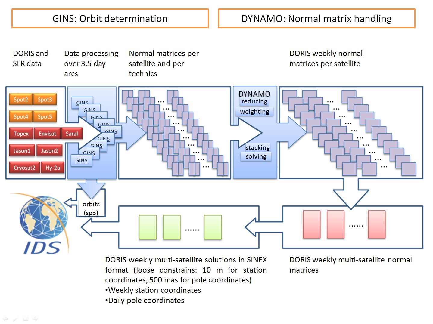
We use GINS/DYNAMO software package for the satellites orbit determination and for the computation of 3.5-day NEQ residuals. Weekly station positions and daily ERP are solved together from 7-day NEQ systems.
Models and standards
The table below gives the list of models and standards applied for the processing of the grgwd40 series for the contribution to the ITRF2014.
| Data Analysis Summary of the DORIS weekly SINEX series used in the IDS combination for the realization of ITRF2014 | ||||||
| Sinex Series | ||||||
| Name | grgwd40 | |||||
| Description form | TBD | |||||
| Analysis Center | ||||||
| Name | CNES/CLS | |||||
| Contact | H. Capdeville | |||||
| Additionnal contacts | J.M. Lemoine, L. Soudarin | |||||
| Software | ||||||
| Name and version | GINS v 13.2d1 | |||||
| SINEX Method (NEQ or COV) | COV | |||||
| Data weights (data reduction) | 0.3 mm/s | |||||
| If COV, Station Constraint | 10 m | |||||
| If COV, EOP Constraint | 15 m | |||||
| Satellite | ||||||
| satellites included in weekly SINEX | start-end | |||||
| SPOT2 | 03/01/1993 - 18/07/2009 | |||||
| SPOT3 | 30/01/1994 - 16/11/1996 | |||||
| SPOT4 | 03/05/1998 - 22/06/2012 | |||||
| SPOT5 | 16/06/2002 - 31/12/2013 | |||||
| TOPEX | 03/01/1993 - 30/10/2004 | |||||
| ENVISAT | 21/07/2002 - 07/04/2012 | |||||
| JASON1 | 31/10/2004 - 12/07/2008 | |||||
| JASON2 | 13/07/2008 - 31/12/2013 | |||||
| CRYOSAT2 | 20/06/2010 - 31/12/2013 | |||||
| HY2A | 02/10/2011 - 31/12/2013 | |||||
| SARAL | TBD | |||||
| Arc cut | ||||||
| Arc lengths | 3.5 days nominally (minimum 1 day) | |||||
| Handle of Manoeuvers | Break arc and Restart at 12am or 12pm; estimated from 2012/01/01 | |||||
| Handle of Data gaps | Arcs truncated for large data gaps and Restarted. | |||||
| Additional margins | 6hrs before and 6 hrs after for POD but not in SINEX | |||||
| Reference System | ||||||
| Earth reference system | DPOD2008v12 | |||||
| Celestial reference system | inertial J2000 | |||||
| Polar motion and UT1 | IERS C04 08 | |||||
| Background C21, S21 | ||||||
| Pole model | ||||||
| Precession/Nutation | IERS 2010 using NRO origin | |||||
| Station coordinates | DPOD2008v12 | |||||
| Displacement of reference points | ||||||
| Solid Earth tidal displacement | IERS 2010 Conventions | |||||
| Ocean loading | FES 2012 | |||||
| Tidal atmospheric loading | S1/S2 Ray & Ponte (2003) | |||||
| Non tidal atmospheric loading | none | |||||
| Solid pole tide displacement | IERS 2010 Conventions | |||||
| Ocean pole tide displacement | none | |||||
| Tidal Geocenter | ||||||
| Satellite reference | ||||||
| Mass and center of gravity | initial values and time evolution from IDS files "sat"mass.txt | |||||
| Attitude Model | nominal laws | |||||
| Gravity | ||||||
| Gravity field (static) | EIGEN-6S2 | |||||
| Gravity field (time varying) | EIGEN-6S2 up to degree 95 including time variable terms up to degree 50 (bias & drift per yr from 2002 to 2012, periodic 18.6, 1, 0.5yrs) | |||||
| Solid Earth tides | IERS 2010 conventions | |||||
| Ocean tides | FES 2012 (32 principal waves, + 60 admittance waves) up to degree 50 | |||||
| Atmospheric gravity | 3hr ERA-interim / ECMWF up to degree 50 | |||||
| Air Tides | ||||||
| Non tidal oceanic gravity | TUGO R12 up to degree 50 TUGO R12 up to degree 50 | |||||
| Atmospheric tides | none (considered through the ECMWF atmospheric data) | |||||
| Earth pole tide | IERS 2010 conventions | |||||
| Ocean pole tide | Desai 2002 up to degree 12 | |||||
| Third bodies | Sun, Moon, Mars, Venus, Jupiter, Saturn, Uranus and Neptune ephemeris : DE421 (JPL) | |||||
| Surface forces and empiricals | ||||||
| Radiation Pressure model | Thermo-optical coefficient from pre-launch box and wing model, with smoothed Earth shadow model; models from CNES document for all satellites except tuned macromodels for Spot-2, -3, -4, Jason2 | |||||
| Radiation pressure scale coefficient | 1 coef/day but strongly constrainted (1. e-4) to: 1.03 for Topex; 1.07 for Spot-2; 1.07 for Spot-3; 1.16 for Spot-4; 1.05 for Spot-5; 1.05 for Envisat; 0.94 for Jason-1, 0.97 for Jason-2; 1.00 for Cryosat-2; 1.13 for HY-2A | |||||
| Earth radiation | Albedo and IR pressure values interpolated from ECMWF 6hr grids | |||||
| Atmospheric density model | DTM 94, with best available solar activity | |||||
| Drag coefficients | Adjusted; Spots, Envisat, Cryosat2, HY-2A: 1 coef/4 hours (1/1hr in high solar activity periods) ; Topex,Jasons: 1 coef/half day | |||||
| 1/rev empiricals | 2 coeff cos-sin /orbital period in normal direction ; 2 coeff cos-sin /orbital period in tangential direction ; per arc | |||||
| DORIS measurements | ||||||
| Troposphere Model | GPT2/VMF1 | |||||
| Weather (meteorological data) | ||||||
| Troposphere mapping function | ||||||
| Troposphere correction | One zenith delay/pass (wet tropo scale factor adjusted) + one daily tropospheric gradient per station in North & East directions | |||||
| 2nd order ionosphere | Not applied | |||||
| Frequency | 1 frequency bias adjusted per pass | |||||
| Relativity | Schwarzschild model + Lense-Thirring + geodesic precession | |||||
| Weight | models: 0.3 mm/s; measurements: derived from observation standard deviation in data files | |||||
| Elevation angle cutoff | 12 degrees | |||||
| Downweighting law | Downweighting law for elevation <= 20 deg; Weight of the observation is multiplied by the factor elevation**2/400 with elevation in degrees) | |||||
| Satellite system | Center of mass - antenna phase center vector computed from macro model + attitude law; no phase law applied | |||||
| Ground system | Phase centre / reference point vector from manufacturer values; phase law applied (Alcatel, Starec version 2013) | |||||
| DORIS System Time Bias | ||||||
| South Atlantic Anomaly | Corrective model for Jason-1; corrected measurements for Spot-5 from 2006 only | |||||